
For those who prefer ‘the road less traveled’ (which translates into fewer trekkers on the trail) and who enjoy pushing themselves physically and mentally, the Manaslu Circuit Trek in Nepal might just be the trek you are looking for!
Of course, it is not just about driving and motivating yourself; it’s also about the spectacular scenery, the thought-provoking cultures and lifestyles of interesting locals you will meet, and the camaraderie with your guide.
This complete Guide will give you all you need to know about the Manaslu Circuit Trek to enable you to make an educated decision as to whether this is the right trek for your adventure in Nepal.

The Manaslu Circuit Trek: The Basics on What to Know Before You Go
- Location: central-western region of Nepal in the lap of Mount Manaslu, situated within the Manaslu Conservation Area Project (MCAP)
- Starting point: departing Kathmandu for a 7 hr bus journey, the trek starts from Soti Khola and ends at Dharapani for the return bus journey
- Duration: 13 Days
- Trip grade: challenging
- Max altitude: 5,167 m / 16752 ft (at Larkya La Pass)
- Accommodation: basic trekking lodges known as teahouses
- Food: basic curry, noodles, soups, and porridge in the majority of teahouses, but tasty and plentiful
- Distance: 180 km
- Total incline: 11,000 m
- Total decline: 9,800 m
- Permits: Manaslu Conservation Area Permit, Annapurna Conservation Area Permit (as you are also entering this region) and a Restricted Area Permit
- Guide and Porters: you must trek with a guide in this region. Porters can also be hired through your trekking company, Magical Nepal, and it is possible to share a porter with a fellow trekker. Note that one porter can carry no more than 20kg in total.
Important Points to Consider on the Manaslu Circuit Trek
Here are some important points to know before you go. Nepal is one of the top adventure destinations in the world, and this trek is sure to show some of its best facets.
Manaslu Circuit Trek Difficulty
Let’s discuss the difficulty of this trek in more detail. If you are a regular hiker and particularly if you have trekked in the Himalayas before, you will have a good idea of your capabilities. This trek starts at an altitude of 800m / 2,624 ft and gradually, by daily increments of around 400m/ 1,312 ft, brings you to the height of 3,000m / 9,842ft on Day 6.
Daily, expect to walk around 6 hours, with a few days of longer walking. Crossing the Larkya La Pass at 5,160m / 16,929 is not only stunningly beautiful but the hardest day with 10 tough hours of walking.
Although it is around 3,000m when us humans may begin to feel some adverse effects such as a headache, with the built-in acclimatization days, altitude should not be a problem for the majority of healthy trekkers. We must add, however, that altitude-related problems are real, and every care is taken to ensure our guests’ safety, and we train our guides to recognize symptoms before they become serious.
The Manaslu Circuit is Remote
One of the main attractions of the Manaslu Circuit trek is that it goes through remote countryside and gets fewer trekkers than many of the other treks in Nepal. Although remote, it is only one day’s road journey from Kathmandu – no need for weather-dependent flights.
Another result of its remoteness and reduced numbers of trekkers is the fact accommodation is more basic than in more commercial areas. There will be a bed, a blanket, a shower, a reasonable food menu, and the necessary to recharge your electronic goods. Nothing fancy, but more than adequate!
Manaslu Circuit Weather
The Manaslu Circuit Trek starts at a low altitude with subtropical forests and weather. The days get cooler the higher you go until you reach, very possibly, snow underfoot at the Larkya La Pass. Like the majority of treks in Nepal, the best months to come are March, April, May, October, and November.
Clothing for the Manaslu Circuit Trek
See the packing list below for more details, but basically, layers to fit the warm lowland weather and the cold mountain climate, good (pre-worn) trekking boots, and we can also recommend a sleeping bag for extra warmth and hygiene! Available to buy or hire in Kathmandu.
Manaslu Circuit Scenery/ Wildlife and Culture
If it’s a cardio workout you want, we can suggest your local gym! But seriously, the main attraction on a trek in Nepal is the mountains! Manaslu is the eighth-highest mountain in the world, standing at 8,156 m (26,759 ft), and is surrounded by other huge Himalayan peaks, including Himlung and Annapurna II.
From the Larkya La Pass, there are jaw-dropping views of glaciers, a glacier cirque (possibly formed by ancient avalanches) and Himlung Himal, Gyaji Kang, and other great mountains.
At the start of the trek, you will travel through lowlands of rice and millet terraces and the Budi Gandaki gorge with waterfalls and plenty of suspension bridges to add to the fun.
Aside from the landscape, this conservation area is home to the Snow Leopard, Himalayan Marmot, Pika, Tahr, and many other species. It is also home to different Tibetan and Nepalese ethnic groups, making it a real cultural experience as well, particularly if you are interested to learn more about Tibetan Buddhism.
Wi-Fi and electricity on the Manaslu Circuit
Wi-Fi is not guaranteed. There’s no point arguing at the teahouse about it. Carry a local SIM card, which will be able to access the internet at lower altitudes. Electricity may be provided by solar, and you will be charged anywhere up to $5 USD per item to recharge your phone, camera etc. Carrying a good power bank is highly recommended.


Manaslu Circuit Highlights in a Nut Shell
- The overall beauty of the flora in both lowlands and high mountains
- Potential sighting of unique wildlife in two conservation areas
- Getting up at 3am to cross the challenging Larkey La Pass
- Being surrounded by some of the highest peaks in the world
- The mighty thundering Budi Gandaki River, waterfalls and hanging suspension bridges
- Seeing Tibet in the distance
- Feeling like the first trekkers to visit this remote area
- An astounding glacial cirque
- Meeting different groups of locals and learning of their culture
- Visiting Pungyen Gompa (monastery)
Packing List for Manaslu Circuit
Here is an exact packing list for this trek! See my hiking essentials post for links.
- 2 x Trekking pants, preferably those that zip down to shorts
- 1 x Warmer hiking pants for colder areas
- 1-2 x Long sleeved quick drying trekking shirts
- 1-2 x Long sleeved thermal shirt/ vest
- 2 x t-shirts
- 1 x Thermal long underwear
- Underwear for the duration (perhaps you will wash some out a couple of times, but consider the drying process)
- 2-3 x socks, including heavy duty wool ones
- 1 x Lightweight jacket for low altitude and warm days
- 1x Heavy down jacket
- 1 x Warm hat
- 1 x Cap for the sun
- Trekking poles (handy even if you are spectacularly fit!)
- Sunglasses
- Scarf/ buff and gloves
- Hiking boots (pre-worn)
- Microspikes (available in Kathmandu)
- Headtorch
- Sunscreen
- Water filter or sterilising drops/ tablets
- Powerbank
- Camera/ phone/ etc
Manaslu Circuit Trek Outline Itinerary, Altitudes and Times at a Glance
Day 1: Kathmandu to Maccha Khola (Drive)
Maccha Khola – 930 m / 3,051 ft – 7 hrs
Day 2: Maccha Khola to Jagat
Jagat – 1,340 m / 4,396 ft – 6 hrs
Day 3: Jagat to Pewa
Deng – 1,804 m / 5,918 ft – 6 hrs
Day 4: Pewa to Namrung
Namrung – 2,630 m / 8,628 ft – 6 hrs
Day 5: Namrung to Lho
Lho – 2,957 m / 9,701 ft – 4 hrs
Day 6: Lho to Sama Gaun
Sama Gaun – 3,530 m / 11,581 ft – 4 hrs
Day 7: Acclimatization Day (Day Trip to Manaslu Base Camp or Pungyen Gompa) Sama Gaun – 4,400m / 14,435 ft – 7 hrs
Day 8: Sama Gaun to Samdo
Samdo – 3,865 m / 12,680 ft – 3 hrs
Day 9: Acclimatization Day (Day Trip to Tibet Border)
Samdo – 5,000 m / 16,404 ft – 8 hrs
Day 10: Samdo to Dharmasala
Dharmasala – 4,460 m / 14,632 ft – 4 hrs
Day 11: Dharmasala to Bimthang via Larkya Pass
Bimthang – 3,590 m / 11,778 ft – 10 hrs
Day 12: Bimthang to Dharapani
Dharapani – 1,970 m / 6.463 ft – 7 hrs
Day 13: Dharapani to Kathmandu (Drive)
Kathmandu – 1,300 m / 4,265 ft – 8 hrs
Breakdown of the Day to Day Highlights on the Manaslu Circuit Trek
Day 1: Kathmandu to Maccha Khola (7 hours drive)
The day starts off from Kathmandu, where we get a local bus along the Prithvi Highway until we reach the village Machha Khola, where we stay overnight. The alternative would be to hire a private jeep, which would be more comfortable.
Highlight of the day: the only real highlight is that you are off on your adventure! The scenery is pretty cool, too, although the road is dusty and bumpy in places.
Day 2: Maccha Khola to Jagat (5 to 6 hours hike)
Now, the trek begins! Follow the banks of the Budi Gandaki River along a dusty, twisting trail. You will get your first experience of suspension bridges as you cross and recross the river. The villages you see on the way are Gurung villages, with some steep stone stairs on the way.
With aching muscles, now you are really trekking! It is most likely a hot and sweating hike today. If you wish, you can rest and soak your legs in a hot water spring at Tatopani (literally translated to hot water).
Highlights of the day:
● Experiencing those suspension bridges!
● The mountains overhead.
Day 3: Jagat to Pewa (5 to 6 hours walk)

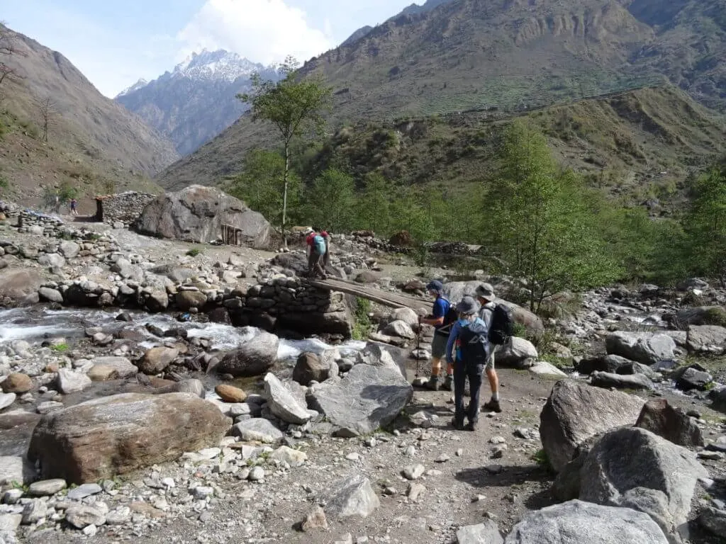
Still in the sub-tropical forests, where it is surprisingly warm, it is a definite benefit if your limbs are sore from yesterday! Buddhist prayer flags decorate the trails, and there are some interesting gompas (monasteries) on the way.
At a large Gurung village called Phillim, you will get your permits checked (just to make sure you have paid for the right to be here)! Rhododendron forests are colorful to hike in the spring. Crossing the Siyar Khola bridge, you come to the junction which leads to the interesting Tsum Valley (an adventure for another occasion, perhaps).
Pewa is a very small settlement with basic food, the best option being the delicious Nepali cuisine of dal bhat and pickles.
Highlights of the day:
● The highlight is always the mountains reaching high into the heavens.
● Rickety old suspension bridges that test our nerves.
● Prayer flags fluttering in the wind.
Day 4: Pewa to Namrung (5 to 6 hours walk)

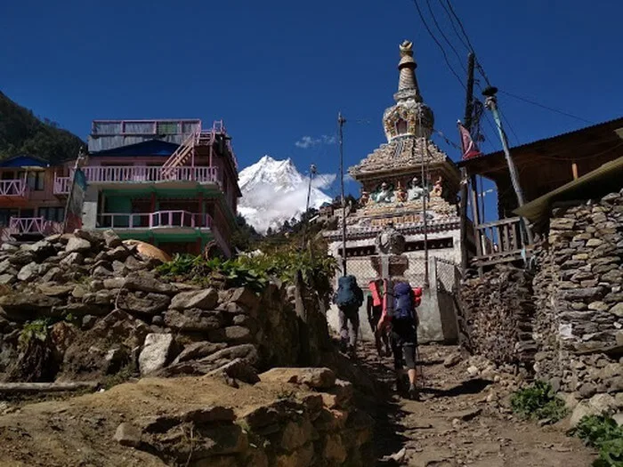
The trail takes you through a bamboo forest, across another suspension bridge, and a climb up to more villages. Look out for monkeys on the way! Now, you enter a landslide zone where you have to pay attention to the guide who will get you safely across.
Then, it’s an uneven zigzag trail up to Namrung. The trail proceeds to Ghap through several more landslide zones. At this point, you must be extra careful as you walk. Plus, you must be attentive to your guide’s instructions to maintain physical safety. After the landslide zone, you follow the trail up to Namrung. By now, the views are of major peaks, which your guide will point out to you.
Highlights of the day:
● Looking out for monkeys on the way, but please don’t feed them.
● A kind of highlight is making it safely across the loose stones of landslide-prone areas.
● Having a good coffee at a modern restaurant in Namrung, should it be hopefully open. ● The Wi-Fi can be pretty good at Numrung. Again, hopefully!
Day 5: Namrung to Lho (3 to 4 hours walk)
More gorgeous rhododendron forests, together with forests of oak. Perhaps more interesting are the arched gates, prayer (mani) walls, and local Nurbri people dressed in Tibetan-like attire. If you look up, there are wonderful views of Manaslu and Manaslu North.
Now, at high altitude, you might begin to feel some slight ill effects such as a headache. Take note of this and advise the guide should it get worse. By walking steadily and slowly, and ensuring everyone is drinking plenty of fluids, the guide is well aware of the rise in altitude.
Highlights of the day:
● First views of Manaslu up close.
● Feeling of peace amongst Buddhist peoples.
Day 6: Lho to Sama Gaun (3 to 4 hours walk)


Waking up to views of Manaslu and knowing it is a short day’s walk to Sama Gaun with its yak pastures, large gompa and shops brings a smile to your face.
Highlights of the day:
● Walking through high alpine pastures with lots of grazing yaks there and on the nearby mountainsides.
● Shopping! Perhaps for some snacks, if anything that is available catches your eye. ● Best views so far of Mt Manaslu – and from your teahouse!
● Wi-Fi, hopefully!
Day 7: Acclimatization Day (Day Trip to Manaslu Base Camp or Pungyen Gompa, 7 hours walk)


Now, at an altitude of 3,530 m / 11,581 ft at Sama Gaun, it’s time to let your body adjust before going higher. The best way to acclimatize is to keep active! So, no, put that book away and put the hiking boots back on!
There are a couple of options. The first is hiking to Manaslu Base Camp, passing Birendra Tal (lake). The second option is to hike to Pungyen Gompa. The Gompa sits on the top of a plateau facing the mountains and is best visited for sunrise.
If you are feeling particularly tired and really do need to rest more than hike some more, you can make a shorter trip to just Birendra Tal, which provides something different to enjoy and experience.
Highlights of the day:
● If you head to Puneng Gumpa, eating your packed lunch while gazing at the mountains has to be a highlight!
● There is also a possibility of seeing foxes in this area.
● By hiking to Manaslu Base Camp, there is a wonderful feeling of achievement as well as stunning mountain views.
Day 8: Sama Gaun to Samdo (2 to 3 hours walk)
Although a short day in terms of hours, the going is tough because of the altitude. Leaving the tree line, you climb a ridge and cross a wooden bridge over the Buri Gandaki River to reach the picturesque yak herding village of White Kani. Then on to Samdo. Since it has been a short day, you can walk on and visit Samdo Peak if you desire.
Highlights of the day:
● Passing the mani walls with their Tibetan Buddhist mantras carved into them.
● Bird watching, as there are plenty of different varieties in the area.
Day 9: Acclimatization Day (Day Trip to Tibet Border, 8 hours walk)
After what was probably a cold night at Samo (this is where your own sleeping bag would be extremely helpful), you will be more than happy to strap on your boots and head out. Standing at the Tibet / Nepal border, there are views of Samdo Glacier and perhaps even some yak caravans.
Unfortunately, there are no signs saying ‘Welcome to Tibet’ to photograph, but you will be able to say you have seen Tibet! Do not be tempted to climb over the rickety fence into China!
Highlights of the day:
● Seeing Tibet!
● Gazing at the Samdo Glacier.
Day 10: Samdo to Dharmasala (8 hour walk)
Trekking through rugged terrain with the mountains overhead has now become second nature! It is likely the mountains are covered in fresh snowfall, making it all the more magical. Dharmasala is another cold settlement to spend the night.
Highlights of the day:
● Knowing that the interesting and challenging Larke La Pass is coming up!
● Being grateful for that extra thick jacket you packed before leaving home!
Day 11: Dharmasala to Bimthang via Larkya Pass: (10 hour walk: This is the highlight of the Manaslu Circuit Trek! And it will be a real challenge!)

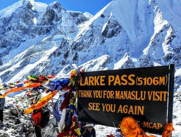
Larkya La Pass is 5,160m / 16,929 ft and most likely covered in snow. It also involves getting up around 3am to make it over the pass before the high winds come up in the afternoon. Micro-spikes are mostly used for this crossing, which is another new experience for many people.
As for the views, you will see Himlung (7,126m/ 23,379 ft) near Tibet Kang Guru (6,981m /22,903 ft), and Annapurna II (7,937m / 26,040 ft) – all of which will take your breath away. On the descent, there are views of mountains and ice falls surrounding you, along with several glaciers.
Highlights of the day:
● It’s probably not a highlight to get out of bed at 3am, but once you are up, the excitement builds!
● Prayer flags greet you as you reach the top of the pass, making you feel like you are a Himalayan mountaineer.
● Using micro-spikes on the descent brings more adventure to the day.
● Finally reaching the teahouse at Bimthang for some hot tea and great conversation.
Day 12: Bimthang to Dharapani (7 hours walk)
The final day of the trek, so enjoy the forests and the rhododendron bushes. As you descend, the landscape turns from glacial flood areas and forests to agricultural lands. It is a long downhill hike of around 25km, but you can breathe more easily at the lower altitude. Reach Dharapani for your final night in the Manaslu area.
Highlights of the day:
● Bittersweet feeling of having completed the trek successfully.
● Perhaps a beer to celebrate at the final teahouse.
● Exchanging contact details with fellow trekkers.
Day 13: Dharapani to Kathmandu (8 hours drive)
A jeep at Tilije will take you to Beshi Sahar, where you catch the bus back to Kathmandu. Or arrange for a private jeep to meet you. You probably deserve that!
Highlight of the day:
● Another bittersweet day but with the promise of a really hot shower in clean surroundings back in your hotel in Kathmandu.
● Menu choices you now find so exhaustive it’s hard to choose!
Further Information on the Manaslu Circuit Trek
For further information of the Manaslu Circuit Trek, and other treks in the area, such as the Tsum Valley Trek and Manaslu and Tsum Vally Trek, or if you have any questions, contact Magical Nepal, who have amazingly experienced guides and friendly service. We hope to see you in the mountains soon!

Passionate, full-time travel blogger with over 230k on social media and 150kMPV blog. Extraordinary photographer with two DSLR's + a drone with a love for capturing candid moments, epic drone shots, and magical compositions. I'm a natural-born content creator originally from California, but I've been on the road for 9 years living, working, traveling, blogging, and photographing my way around the world. I recommend the most amazingly adventurous and unique + boutique travel experiences/stays and helpful products to my audience and write comprehensive guides on my website that have helped millions of travelers so far. I love to inspire people to plan their dream trips, and many readers have given feedback as such. The reach on my platforms continues to soar, especially when combining cutting-edge social content with optimized articles on my high-authority website.